Tuesday, April 28, 2009

Amabilis Mountain ..

Ken had organized a mellow outing up Amabilis so that people could either ski or snowshoe. The road up or in has not been groomed yet, so I made the decision to bring fat skis. There were six of us on the trip and it was split with two people snowshoeing and the rest skiing. We had a casual start, and didn't leave Seattle until 8am. With a few stops on the way, we were finally on snow around 10am and headed up the road.

The road conditions down low

Despite the recent warm weather and rain, there was enough coverage down low. Shortly after getting on the road to Amabilis, there were a few dirt patches, but there was adequate coverage from previous skiers to keep going up a track that was put in by multiple parties before us. We skied up under cloudy skies and hoped that they would turn "partly sunny" like the forecast had told us. While the coverage was nice on the road, snow depth in the trees was minimal. The snow on the road had a packed section where people had previously traveled, but the snow was deep and mushy outside of that section.

Upon reaching the intersection for the loop of the upper mountain, two of our party decided to turn around. Liz turned around because she had Nordic skis which just weren't ideal for the situation. And Jack turned around due to blisters from his boots. This was his first time using his AT setup to skin. After our little break the rest of us continued upward, choosing a clockwise direction to complete the loop.

In the woods near our turn around

The conditions got worse from there as there were few people who had gone up that section of trail. The snow had a breakable crust which wasn't good for the two remaining skiers or the snowshoers. It took a long time for us to continue up while the weather worsened. When we finally made the last section of woods before our turnaround, a cool mist was wetting us and I quickly put on a rain shell. In moments we had reached our turn around point, where I donned another layer under the shell. We all had a quick snack/lunch. While us skiers transitioned into downhill skiing we discussed with the slowshoers that we would wait for them at the intersection of the top loop.

And away we went. The skiing was surprising not horrible. With a slightly steeper road than on Mount Catherine, I was able to glide without a whole lot of double poling. But Ken and I did have to remain in the track otherwise we would slow to a stop. A few portions were difficult to maintain speed as they were lower angle or the track wasn't wide enough for both of my skis. Had we not had to wait for the snowshoers, Ken and I would probably have returned to the parking lot in a little over and hour.

The ski out

After a certain distance, the track widened, and was more compact and our speed picked up. I had to occasionally snowplow in order to maintain speed. Sometimes you could just steer into the deeper snow to lose some speed, but this practice proved to be a little difficult as you didn't know what to expect outside of the track. Once closer to the intersection, the packed swath of road was wider and more firm. I really picked up speed on this section without trying. And the last stretch into the meeting point was all snow plow. Ken followed behind me and attempted to scrub speed by sticking a ski into the deeper snow off the packed section. He started to lose control and laid down instead of continuing toward the immanent crash.

Ken on a faster section of the road

We waited a long time before our snowshoe friends arrived. We greeted them and asked if they needed anything. They didn't. And we were on our way. I got to the car in about 20 minutes from that point, and that even included one stop to rest my legs and a short uphill that I had to side step. The lower section of the road had some good snow and the packed section comprised more of the road in certain areas to the width where I could actually make small turns. Before I knew it, it was over and we were back at the parking lot where Liz and Jack were waiting. Once again we waited for the snowshoers, and then it was time to head back to Seattle.

Jennifer and I had done this trip with Gabriel and Lindsay a few years ago. At the time I was new to skiing and debated about trying it on my skinny skis. I opted not to and stuck with snow shoes. After seeing Gabriel's ease of skiing it, and the relative easy conditions, I had wished at the time I had attempted it on skis. While it would be interesting to try it with a Nordic ski, they weren't the right option for today's conditions and I was happy to have my backcountry skis which did not inhibit my performance at all.

Saturday, April 25, 2009

Of Sand, Wood and Crossing State Lines: The Quest for a Curvy Fork

Grand Bois Fork Crown & Kaisei Toei Blades
Because I like to keep things simple, the bicycle I am making is of course a low trail design. And low trail means a fork with a lot of rake. A very curvy fork, in other words. Not only did I want it to be curvy, but I wanted it to be that special kind of French-curvy where instead of a gradual "banana" bend, there is a dramatic flick toward the tips of the blades (like so).


Grand Bois Fork Crown & Kaisei Toei Blades

When you buy supplies for making a fork, what you get is two straight blades that are (hopefully) a bit longer than you need them to be, and a crown which those blades plug into. It is then up to you to rake the blades. The style of bend I wanted requires using blades that are designed to withstand such dramatic manipulation. I went with the Kaisei Toei blades, which were already familiar from other projects I've been involved in.


Circle A Shop Cat

To get the fork blades bent as desired, we needed a special setup that was not locally available. So we payed a visit to Cirlce A Cycles in Providence RI, about 30 miles from Mike Flanigan's shop. They have a fork bender that was made specifically for the French-style bend and could produce the 73mm of rake I wanted. The furry receptionist granted us permission to use it.


Chris Pours Sand Into Fork Blade

Since 73mm is a pretty dramatic amount of rake, Chris Bull suggested filling the fork blades with sand before bending. This would reduce the possibility of damage during the process.


Sand-Filled Fork Blade

The blades were taped at both ends to contain the sand.


Preparing to Rake Blade

The fork bending press consists of a wooden block curved according to the French bend design (they have several of these presses, used for different styles of bends). There is a notch along the curve where the fork blade sits, held in place by a vise.


Raking Fork Blade

A giant lever is then pushed up, forcing the blade to adhere to the curvature of the wooden block.


Raking Fork Blade

The further up you push, the more dramatic the bend.


Checking Rake

At first we did not have an idea of exactly when to stop, so Chris eyeballed it and stopped when he thought the rake was around 50mm. Confirming that this was correct and that the bend was forming properly, he then continued the process until we finally had the 73mm rake we wanted.


Checking Rake

This is the dropout placement mockup. To determine the rake correctly, you need to know how and where the blade will be connected to the dropout.


Circle A Bent My Fork

One thing that can go wrong during this process, is that the steel can get distorted. When this happens, you can see and feel a rippling on the inside of the bend. Thankfully this did not happen.


Raking Fork Blade

For the second blade we now knew exactly when to stop and had a marker in place. I did part of this bend myself and it was pretty cool to feel the blade give under the force of the lever. It is interesting that Circle A's setup makes you push the lever up rather than pull it down; I have never operated this kind of press before.


Circle A Bent My Fork

Thanks to Circle A, I now have two symmetrical, beautifully raked fork blades that are waiting to become a fork. All I have to do is braze it.

Friday, April 24, 2009

House on Fire


After our "rest" day with minimal hiking and another soak in a hot tub last night, we were ready for another full day of hiking adventures. Our first hike of the day brought us to Mule Canyon on Cedar Mesa, to an ancient Anasazi ruin known as the "House on Fire". Since we were now at a higher elevation than we had previously been on the trip, the environment was a bit different from what we had seen so far. Mule Canyon was a beautiful hike with a LOT of trees and shrubs and even a little bit of water in the canyon. It was a shock to do a hike with so much vegetation, because most of the hikes we had done so far were in open desert andextremely dry with very little vegetation.


The hike to the House on Fire ruins was a very pleasant one with minimal elevation change. After about a 1.5 mile walk we rounded a bend in the canyon and immediately noticed the ruins on the right. House on Fire is just one of several ruins in Mule Canyon, and was occupied by the Anasazi. According to literature that we saw about the area, the ruins in Mule Canyon are over 800 years old and have never been excavated or restored in any way. The House on Fire ruin is so named because of the overhanging cliff above the ruins that has patterns in it resembling flames. If you visit the ruins in the morning all of the light illuminating the House on Fire is reflected light from the opposite side of the canyon, which means that the roof above the ruins glows with warm light and contributes to the "fire" look. We found it a fascinating site to visit. We would have loved to hike through more of the canyon to see some of the other ruins but we had a long hike planned within Natural Bridges National Monument so after taking in the wonder that is the House on Fire, we hiked back to the truck and continued on to Natural Bridges.


The Copper Falls Trail

Monday, August 8th - - For some reason, I was quite ambitious today and went on a second hike. This was a 1.7 mile loop through the forest, along the river, with a few stair-steps involved as well as some other downhill/uphill sections where there were some handrails to help provide support. I'm not ashamed to admit that I made ample use of the handrails!


The trail would also cross two rivers in three places on very sturdy foot bridges and we'd see several waterfalls along the way. The pictures I took really do not do it justice. To fully appreciate the area you have to be there – feel the spray from the water and hear the roar of the river as it drops over the ledges and through the narrow passageways that it has carved out over many years. This was one hike that was definitely worth the effort!


A small portion of Copper Falls, which drops about 12 feet, on the Mad River. Like the Tahquamenon Falls, the copper color comes from tannin in the water.


A slightly better angle, but still showing only a small part of the falls.


This view shows it a little better – how the river has carved two paths around and through the stone walls of the canyon - but I think the only way you could get a really good shot of this falls would be by being suspended over the river in front of the falls, with a wide angle lens on the camera!


Flowing in a northeasterly direction, the Mad River essentially “runs into” a stone wall, making an abrupt left turn to the west. Coming in from the east is Tyler Forks. Visualize a rather crooked “T” with Mad River being the long upright part as well as the left hand part. Tyler Forks would be the right hand side of the “T” with a bit of a zig and zag just before and after it meets up with the Mad River.


Brownstone Falls is created when Tyler Forks plunges down 30 feet to join the Mad River. The name Brownstone comes from the color of the rocks surrounding it. They were formed eons ago from lava flows that contained small quantities of iron. Tyler Forks curves off to the right, eastward, above Brownstone Falls.


This picture provides no perspective whatsoever! But, there is the Mad River coming in at the top of the picture. The “whitewater” at the bottom of the image is actually Brownstone Falls dropping over the edge of a 30 foot cliff, plunging down and meeting up with the Mad River. Together they continue their journey as Mad River, veering off to the right (where the white foam is in the center of the photo). The sound was incredible. Not nearly as loud as Niagara Falls by any means or even Upper Tahquamenon Falls, but the sound reverberated around the canyon.


Okay, maybe this is a little better. But it still appears as though the water is flowing in from the right and the bottom and going out the top. You'll have to trust me, it isn't.


Adding to the sound of falling water was Tyler Cascades, which is a set of four smaller waterfalls just above and to the east of Brownstone Falls. Simply Gorgeous!


The trail followed Tyler Forks to the east a little ways then crossed at a point just above the cascades. By then the roar of Brownstone Falls was muted and the sound of the water tumbling over the rocks was quite soothing.


Oh, yes! This was one hike that was definitely worth the effort! And I savored every minute of it...


Saturday, April 18, 2009

Snowpack Profile Update. Waffles!

Wow, big news here at the Old Station in Paradise. We now have a computerized weather display running 24hrs and Waffle Weekdays will be starting this week!

The computerized weather display is located inside the Old Station in the windows to the left of the inner door.

You read that right. If you can't get enough of the Mountain during the weekend and can make it up on Friday you can join the ranger(s) in the Old Station for hot drinks and waffles. Start your weekend early between 11 and 3 this Friday, February 10.

Please bring your own cup or mug, donations of hot drinks, waffle makings and fixings will be gratefully accepted (new and unopened) to keep Waffle Weekdays happening.

Now for why you really read this, the snow pack profile update. No failures were observed in either the compression test or extended column test. All layers were fairly dense and well settled.

Sunday, April 12, 2009

Stellar weather and long term forecasts

I found this long term forecast from the Climate Impacts Group. They've done a little weather projecting into the fall and winter (and even the spring). Here is an excerpt,

The seasonal outlooks through spring 2007 suggest... a continuation of warmer than average conditions throughout the region for the coming fall, winter, and spring seasons... pointing toward[s] a weak-to-moderate intensity El NiƱo event for the next few seasons... suggest[ing]... an anomalously dry fall and winter for much of the region.
Of course there were some serious disclaimers, but if you follow this prediction, the forecast doesn't look so hot for skiers.

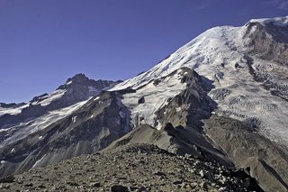
In the meantime, it's warm and dry on the mountain. Camp Muir enjoyed a balmy low of 49 last night! It's at 59 degrees as of 9 AM.

Image by Rob Veal